It's official. WaterFeeler2 has completed its primary mission goals. We are now in an extended mission. That's the good news.
The bad news is that we are currently suffering from low power conditions due to constant bad weather with rain and heavy overcast. The probe still powers up during the day but goes to a shutdown during the night.
Low power caused by bad weather
Let's take a look at the voltage graph first:
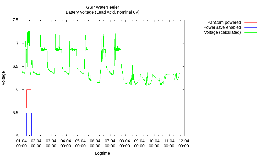
As you can see, there is pretty much no recharging happening. We just get enough energy to run the Arduino and the RF24 radio durin the day. If we take a look at the weather conditions we see why:
Basically, it has been raining for four days. Maybe, if i would have been much more agressive in designing the electronics with powersaving in mind, we could have weathered those conditions. But as it is, i forgot to disable some power leds and the Raspberry Pi/PanCam voltage regulator is on even when the power to the Raspberry itself is off.
And, oh yes, the cheap solar charger is only PWM and does not do MPPT (maximum power point tracking), so we are loosing quite a bit of potential solar power due to that. But there aren't that many affordable MPPT chargers for 6V systems out there. For the next project, i'm probably switching to a more classic 12V off the shelf system - it probably still will not be MPPT due to costs, but you can get reasonably cheap solar panels of a decent size/power for those systems, so just cranking up the panel size might be the cheaper way to go here.
I'm also thinking of designing the next probe electronics (or at least the core part) on a PCB instead of a breadboard/perfboard. This should make it way easier to coat the whole thing in a clearcoat to make it more resistant to condensation (as well as reuable for follow-up projects). Just look at the humidity data:
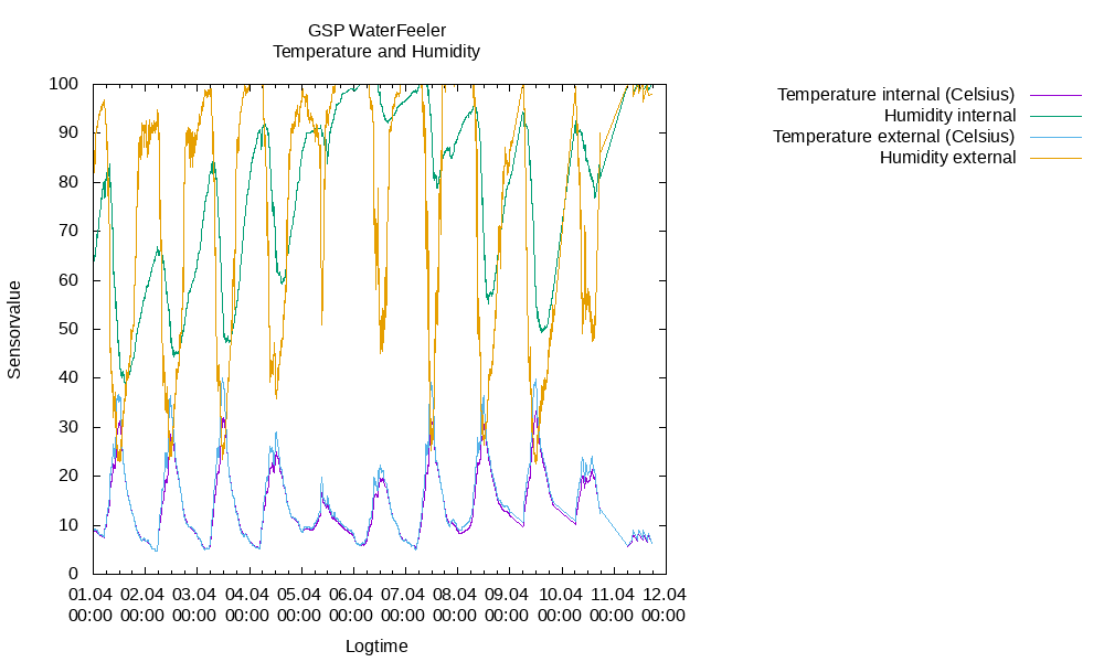
We are pretty much at the upper third of the graph here and we were even hitting the 100% internally. Which means there was condensation. But so far, the electronics keep working. But i'm worried about long term corrosion.
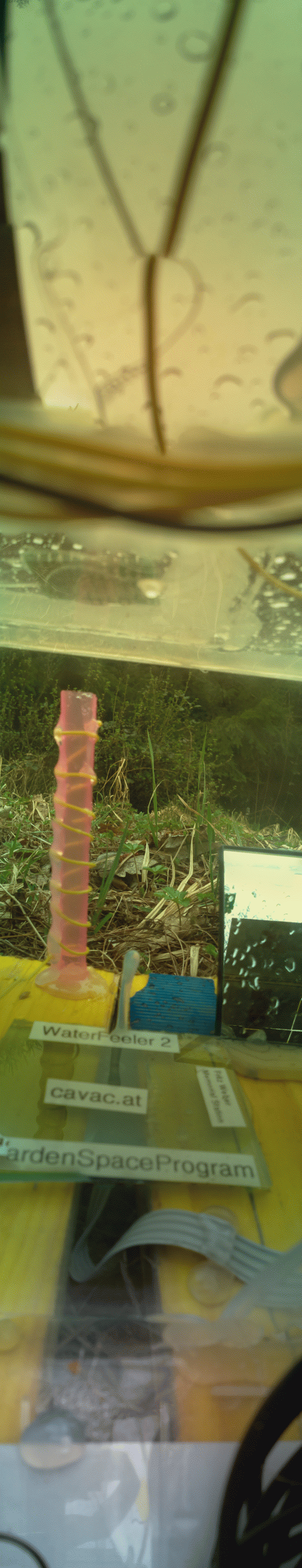
New images
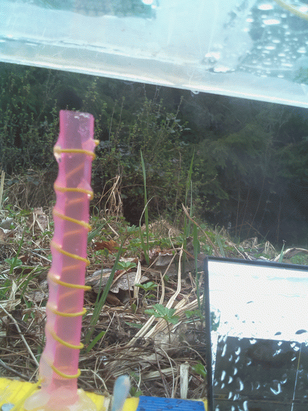
High resolution single frame
I've got a couple of new images to show. The first one is a high resolution single frame image, looking out from the porch. It clearly shows raindrops on the mirror and up on the solar panel. A bit harder to see is the standing water in the RFI antenna (the pink thing with the yellow wire around). It's not up to were the wire comes around to the foreground the first time (so probably less than a centimeter), but we DID collect some rainwater. Yay!
High resolution panorama
This is the panorama of pretty much the same day (taken a minute or two after the above single frame). The light has changed a bit, probably due to a cloud moving in front of the sun. Apart from a wider (higher?) view, one important thing it shows us is that the solar panels are wet, but reasonably clean.
There also doesn't seems to be water pooling in the bottom of the electronics box (the one blob is hot glue, if i remember correctly).
Bad color resolution
You might have noticed on the images above that the color resolution is not the greatest and there is a lot of dithering going on. Part of that is due to image resizing and using and old Raspberry Pi "Version 1" camera.
But i also do suspect that there is something wonky going on with my image processing. Once we get some nice, sunny weather (so we have ample power), i'll see about capturing and downloading some raw images to look into that some more.
I have plotted the color data of the above panorama on a graph:
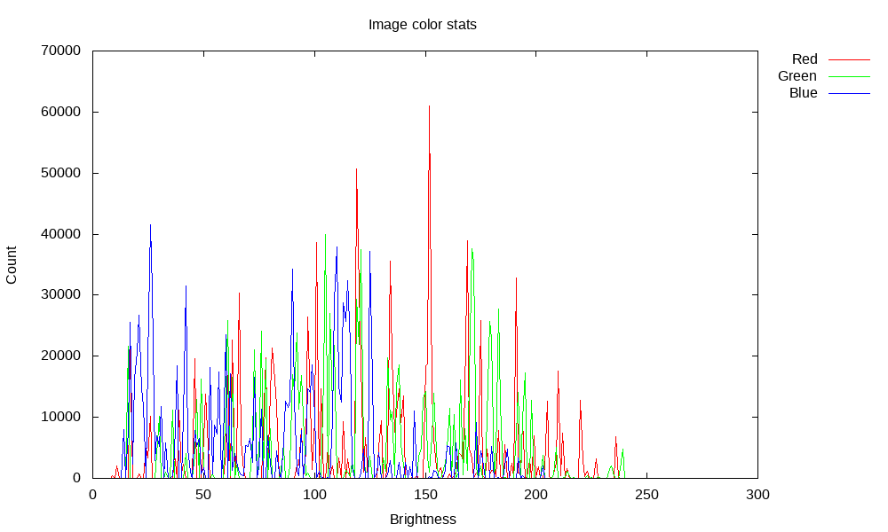
Clearly, only certain brightness values for each color get used, meaning we don't seem to get 8 bit data for each color channel. This certainly looks like an image processing snafu.
Here are the number of "channels" used for each color and the total:
| Bitplane |
Channel count |
| Red |
126 |
| Green |
126 |
| Blue |
120 |
| Total |
372 |
So far, it looks like we are getting only 7 bit resolution per color channel. On the bright side, it's not the problem i feared i was getting, that is accidently using an "indexed" format during processing, which would map the RGB colors to 256 possible color. But still, there is something wonky going on, and i need to investigate more.
Mission status update
Let's take a look at our mission objectives and the status of each one. We got all of the "Required" objectives (although we need to redesign stuff for future missions). Many of the "Desired" ones are checked, the rest is in progress. We even fulfilled three of our "Optional" objectives.
Required
These are the objectives that must the fulfilled. If anyone of these don't work, it's a mission failure.
| Goal |
Status |
Comments |
| Communicate with Mission Control. |
Success |
Reliability and speed better than expected. Can use DGN relais, but works just as well using "direct" mode. |
| Downlink status of internal temperature, humidity and the battery voltage. |
Success |
Works as expected. As previously explained, voltage reading get "strange" during low power conditions due to a design error regarding the drop of the analog voltage reference. Voltage reading still allows checking the overall battery status. |
| Detect precipitation, e.g. rain |
Success |
Detected with the rain sensor as well as downlinked images |
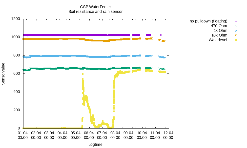
| Measure soil resistance |
Success |
Downlink works as expected. Instrument might need a redesign for future missions based on the data for much better resolution of measurements. |
| Prove solar charging and evaluate power system design |
Success |
Charging works as designed. Due to some engineering oversight on my part, probe can't power down some unneeded devices like status LEDs as well ans the PanCam power regulator. |
| Function for a week |
Success |
Passed with flying color! |
| Take and downlink a low resolution vertical panorama in greyscale (green color channel) |
Success |
On the first day! |
| Run the RFI (radio frequency interference) experiment |
Success |
Instrument detected no 50 Hertz interference, but all tests run so far indicate that the instrument works. This means we don't have to add measures to counter low frequency interference on future mission. Instrument might be able to be repurposed during the extended mission via software updates. |
Desired
These are the nice-to-have objectives. If they don't work or can't be implemented in time, it's sad but not critical. But they must not interfer with the fullfilment of the "required" objectives.
| Goal |
Status |
Comments |
| Detect decreased soil resistance after rain |
in progress |
due ot the lower than expected resolution of the instrument, this needs more data to come to any definitive conclusion |
| Measure soil capacity |
Success |
Measurement worked as a proof of concept and to give some baseline, but due to low resolution and relatively low sample rate of the instrument, this will need to be redesigned for future mission. |
| Prove the ability to act as a radio relais for future missions |
Success |
Relay transmissions using the DGN relais as data originators (senders) have shown that this part of the software works and have helped to refine timings. |
| Function for more than a month with at least one of the science instruments still working |
Success |
Passed with flying color! All instruments still function. |
| Take and downlink multiple low resolution full color panoramas |
Success |
Works |
| Take and downlink a medium resolution greyscale panorama (green color channel) |
Success |
Works |
| Observe cloud movement |
in progress |
Images downloaded so far indicate this is possible. Depends on a future software update to make it viable, though. |
| Observe wind interacting with plants |
in progress |
Images downloaded so far indicate this is possible. Depends on a future software update to make it viable, though. |
| Take and downlink an image of precipitation (rain or snow) |
Success |
Rain collecting on parts of the probe and the underside edge of the solar panel have been observed. |
| Take and downlink an image of condensing humidity in air (fog) |
in progress |
Images downloaded so far indicate this is possible. Depends on a future software update to make it viable, though. |
Optional
These optional objectives are neither urgent nor terribly important. But they could accelerate the Garden Space Program by providing additional data points and early test results.
| Goal |
Status |
Comments |
| Downlink stored test images |
Canceled |
This was deemed "not required" due to the availability of read images taken by the camera. |
| Save a soil capacity time series to EEPROM and restore it later to RAM |
Not yet attempted |
|
| Serve as radio relais for future missions |
Not yet attempted |
|
| Function for more than a year |
in progress |
|
| Take and downlink a full resolution full color panorama |
Success |
As seen in this very blog article |
| Observe an animal |
Not yet attempted |
|
| Upload and activate a firmware update |
Success |
Uploaded version 2 of the Arduino firmware with better powersave handling of engineering data frames |
| Upload and activate a script update for the Raspberry Pi image subsystem |
Success |
Uploaded new versions for more commands, external script handling and "manual servo control" for taking multiple pictures without moving the servo at all. |
tl;dr
"Bad weather is bad for solar power. Pretty images with some color processing flaws. Mission success!"
|